Rogue River Water Levels
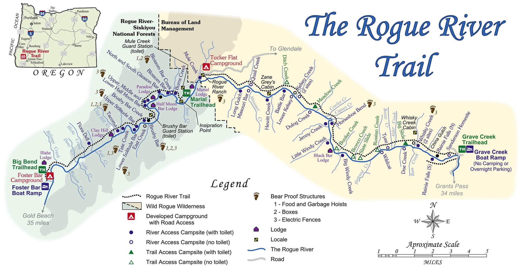
The Rogue River Trail
Bear Camp Road Information
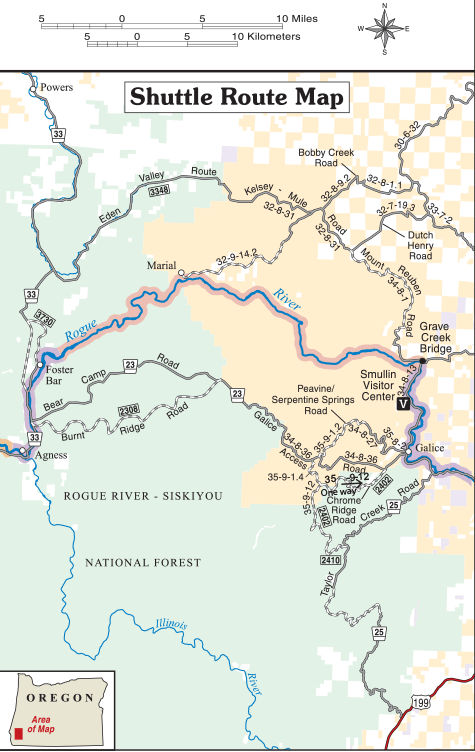
Bear Camp Road/Galice Access Road
Two-way traffic. From west to east, Illahe Road (County Road 375), FS Road 33, Bear Camp Road (FS Road 23), and Galice Access Road (BLM Road 34-8-36). Route takes about 2 hours to travel one way.
Alternate Routes for Bear Camp Road/Galice Access Road
Routes take about 2 to 21/2 hours to travel one way.
Peavine/Serpentine Springs Route:
From west to east, Illahe Road (County Road 375), FS Road 33, Bear Camp Road (FS Road 23), Galice Access Road (BLM Road 34-8-36), Serpentine Springs Road (BLM Road 35- 9-1.2), BLM Road 34-8-27, Peavine Road (BLM 35-8-2), Galice Access Road (BLM 34-8-36).
Chrome Ridge Route:
One-way for traffic heading east from Foster Bar. From west to east, Illahe Road (County Road 375), FS Road 33, Bear Camp Road (FS Road 23), Galice Access Road (BLM Road 34-8-36), BLM Road 35-9-1.4, Chrome Ridge Road (BLM Road 35-9-12), FS Road 2402, Galice Access Road (BLM Road 34-8-36).
Taylor Creek Route:
Two-way traffic. From east to west Taylor Creek Road/Briggs Valley Road (FS Road 25), FS Road 2510, FS Road 2402, BLM Road 35-9-12, BLM Road 35-9-1.4, Galice Access Road (BLM Road 34-8-36), Bear Camp Road (FS Road 23), FS Road 33, Illahe Road (County Road 375).
Eden Valley Route
Route takes about 21⁄2 – 3 hours to travel, one-way
- From Foster Bar Boat Ramp turn right onto FS Road 3730 and travel 6.8 miles north to FS Road 33. Turn right onto FS Road 33 and travel 5 miles to FS Road 3348. Turn right onto FS Road 3348.
- Travel 18.6 miles and FS Road 3348 changes to BLM Road 32-8-31/Kelsey-Mule Road.
- Travel 4.7 miles to Anaktuvuk Saddle and pass BLM Road 32-9-16 (to right), BLM Roads 32-9-16.2 and 32- 9-16.1 (to left), and BLM Road 31-9-35 (to left). Stay on BLM Road 32-8-31.
- Travel 5.2 miles to the junction with BLM Road 32-9-14.2/Marial Road (to right). Continue straight ahead on BLM Road 32-8-31.
- Travel 0.3 miles to the junction with BLM Road 32-8-9.2/Bobby Creek Road (on left). Stay right on BLM Road 32-8-31.
- Travel 4.8 miles to the junction with BLM Road 32-7-19.3/Dutch Henry Road (heading straight ahead and to the right). BLM Road 32-8-31 ends here.
- There is a big wooden sign on the left side of the road at this junction with a map that is accurate and helpful. BLM Road 32-7-19.3 is the road heading to the NE and to the SE. Turn right. Pavement ends here; continue on the narrow, gravel road, and watch out for other vehicles, and log trucks!
- Travel 0.7 miles to the junction with BLM Road 34-8-1/Mt. Reuben Road, continue straight on BLM Road 34-8- 1 and pass BLM Road 32-7-19.3 on the right.
- Travel 7.6 miles to the junction with BLM Road 33-8-13; stay right and continue on BLM Road 34-8-1.
- Travel 3 miles to the junction with BLM Road 33-8-26/Whisky Creek Road; stay left and continue on BLM Road 34-8-1.
- Travel 4.4 miles to Grave Creek Bridge, turn right to cross the bridge and travel 7.2 miles to the town of Galice.
Description and Hazards:
All roads are narrow and winding, through the mountains. Some sections are paved and others are graveled. Not recommended for RVs. Most sections are one-lane with blind curves and turnouts. Always look ahead, as slides, rocks, other shuttle vehicles, and logging trucks may be encountered. There are no gas stations or services along these routes so be prepared with a full tank of gas and plenty of water. Snow usually blocks passage in the winter (November – April). Highway 199 is the winter route. RVs should use Highway 199 year-round.


